Monday, October 5, 2015

Labyrinth at Unity of Tucson


There are lots of labyrinths around Tucson; we can't list them all here. (If you'd like to find others, try the Worldwide Labyrinth Locator.) As Unity's website says, “Unity of Tucson is a Church, School, Bookstore, Wedding Chapel, Health Ministry, and a House of Worship...”

Along the middle of their north-most parking lot (which is graveled) is a sign welcoming you to the labyrinth and asking for quiet. At times when the parking lots aren't emptying or filling, it's definitely quiet.

If you aren't familiar with labyrinths: A labyrinth is a place for meditation… for some people, it's a holy journey. As you walk very slowly around, step by step (it's not a maze; there's only one path through), noticing the details along the way can help make your time there more meditative. For instance, Unity's mural is lined with small colored tiles and some hearts. There's more about labyrinth walking at Walking the Labyrinth: Labyrinth Walking for Spiritual Exercise.


Location: 3617 N. Camino Blanco (south of River Road between Swan and Craycroft), north of gravelled north parking lot

Parking: Parking lots south of labyrinth

Hours: Daylight hours (though it's also magical at night, with a flashlight and city lights in the distance... no other lighting). It's hot out here in the summer, so early mornings or evenings may be best then.

Monday, September 7, 2015

Plaza Palomino

Although Plaza Palomino is a shopping center, it's also a place with benches for sitting (many of them shady at different times of day):


There's a fountain in the middle of the complex:


There are also restrooms, a drinking fountain, and plenty of shops to browse if you'd like.

Location: Southeast corner of Swan & Fort Lowell (not Camp Lowell)

Hours: Business hours (into the evenings when the restaurant — currently closed — is operating)

Parking: Lots on north and south sides (south lot is bigger)

Monday, August 3, 2015

Women's Plaza of Honor

The University of Arizona campus has lots of surprises scattered around (and in) its buildings. Between Centennial Hall and the south side of the Arizona State Museum — just inside the Main Gate, southeast of University & Park — is a long, narrow memorial to Arizona women. (It's also lined with shady spaces — including benches hidden under cool, spreading trees.) You'll probably see the north end first:


That's one of three parts — north, Youth Plaza; center, Maturity Plaza; and south, Seniority Plaza — representing three stages of a woman's life.

As you can see above, the Youth Plaza is a series of arches supported by columns with curved sides. Each arch describes the women memorialized below it. For instance, the arch inscribed Women Lawyers … Women Leaders has two lists of women's names below it, one on each column. Here's one of the two:


The whole plaza is lovingly documented on its website, womensplaza.arizona.edu. There — among many other things — you can look up an honoree by her name (on the Women Honored list) or see lists of the Youth Plaza arches and the women listed under each (for instance, Women Lawyers … Women Leaders).

The central part, Maturity Plaza, is lined with low walls topped by tile mosaics like this:


The plaza was dedicated in 2005:


Location: See first paragraph above

Hours: 24 hours

Parking: Street parking along University Blvd. west of Park Avenue, campus parking.

Friday, July 3, 2015

Fixed location for El Parque de Orlando y Diego Mendoza, and others

The other two blogs I contrubute to, The Tucson Murals Project and Tucson Mailbox Art, have a place near the bottom of each entry that gives its location. You can click on that location to get a Google map.

I've filled in the location box most times I've made entries here on the Tucson's Pocket Parks blog. But today I discovered that the location info hasn't been appearing as it does on the two other blogs. I just fixed that this morning. So, although this particular entry you're reading just now doesn't have a location to click (because this entry isn't about a particular place), most of the others should.

If you'd like an example, have a look at the end of our February, 2015 entry 8 x 18.

See you next month!

Friday, June 5, 2015

Miramonte Park(let)

This place is called a “park,” but I'd call it a pocket park. It's packed with benches, a table with a checkers-chess board, a sandbox, a quote by Emerson along the winding sidewalk, and a Little Free Library at the street corner.


Location: Just southwest of Speedway & Alvernon at the corner of 3rd & Richey

Hours: Daylight hours (I didn't see any lighting in the park)

Parking: Street parking

Friday, May 1, 2015

Aviation Bikeway parklets

Just north of the high-speed road that connects downtown Tucson with Davis-Monthan Air Force Base is a separate path that does the same thing for bicyclists (and pedestrians, and skateboarders, and...). Starting from the west end, you can pick up the path just east of the 4th Avenue railroad underpass and south of the Hotel Coronado. A bit farther east are the Iron Horse park(lets). You'll cross the Rattlesnake (Diamondback) Bridge and the Basket Bridge (here's an article with a great series of photos in the November 15, 2007 article Basket Bridge to be dedicated Friday).

Just after the Basket Bridge, you'll cross the end of Park Avenue and be at the first pocket park. It has a drinking fountain, benches, a bike rack, and shade (although there's no shade for the few colder months that the trees don't have their leaves):


Next stop is at Highland Avenue. There are bike racks, benches and shade, but the water fountain was either shut off or broken when I rode by on January 24th:


A bit farther east is the pocket park under Kino Parkway at 18th Street and Vine Avenue, with a drinking fountain, benches, a bike rack, and often a lot of shade from the overpass. A quiet homeless man is often here with his grocery cart; I took the photo from a distance so I didn't disturb him:


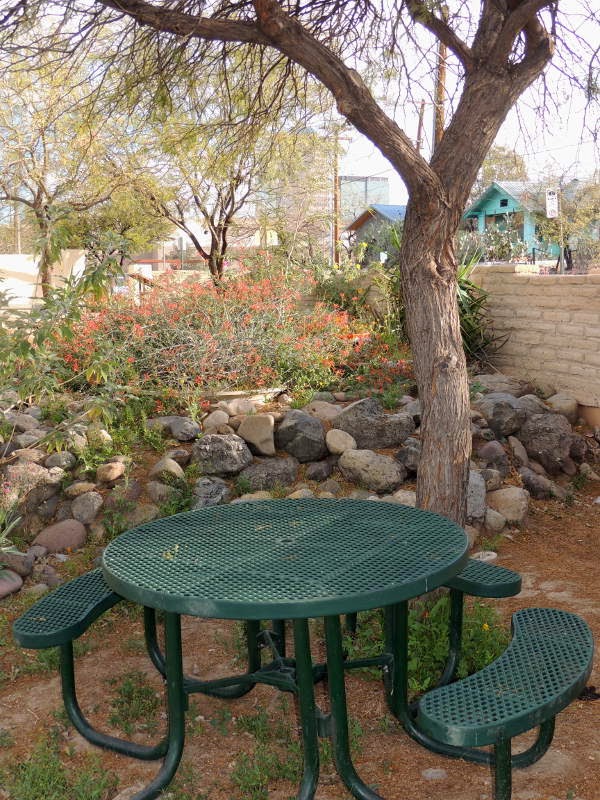
The shadiest spot along the bikeway — maybe not counting Eastmoor Park — is at Wilson Avenue. It also has a drinking fountain, bike racks and benches:


The next stop isn't a pocket park; it's a bigger park, Eastmoor Park, at the south end of Bristol Avenue. It has picnic tables, a water fountain, a bike rack, shade (thought not at the tables), and some mosaic murals next to the bikeway. There are photos on the Tucson Murals Project in the blog entry BBQ at Bristol and Bikeway.

Another few minutes' ride brings you to the parklet on the west side of Country Club — with benches, water, and bike racks... but not much shade:


The farthest east I rode along Aviation Bikeway was the parklet at 34th Street. Again: a drinking fountain, bike racks, benches and shade:


The Veterans Memorial Plaza is close by. Farther east, there may be one or two other pocket parks, but I don't remember seeing them on earlier trips. A big city park you'll pass east of Swan is Freedom Park; it has water and rest rooms.

Location: From the 4th Avenue underpass past Davis-Monthan AFB, mostly north of Barraza-Aviation Parkway and Golf Links Road.

Hours: 24 hours, though mostly deserted at night (with lots of gang graffiti that the city keeps painting over)

Parking: Try along 10th Street, several blocks east of 4th Avenue, for free car parking. You can also park a car at the south end of Park Avenue, south of Broadway... but you'll miss Iron Horse Park, as well the Snake and Basket Bridges, unless you backtrack.

Friday, April 3, 2015

Iron Horse park(lets)

There are several dots of parkland just north of Broadway, east of 4th Avenue. They aren't directly on a city street, and the official address doesn't make much sense. To get there by car, drive along 10th Street and park around the corner with 2nd Avenue. If you ride Aviation Bikeway, or walk the path that starts at the southwest corner of the Coronado Hotel, you'll pass all three park(lets).

To me, Iron Horse Park itself is too big to be called a “parklet.” To the west is “For Speed These Lines," a sculpture by John Davis and Siobhan Roome:


There's no place to sit near the sculpture, but a path winds through it. Have a look at the details in the columns. For a place to sit, head east past the main part of Iron Horse Park to this sitting arc (and bike rack):


It's at the mouth of the Diamondback Bridge. Aviation Bikeway continues from there past Davis-Monthan AFB.

Closer to 10th Street is Iron Horse Community Garden with a pretty mural on the fence in front. (That page is from the Tucson Murals Project blog.)

Location: South of 10th Street, between 2nd and 3rd Avenues

Parking: Street (and bike) parking

Hours: Basically, daylight hours — though there are some lights near (and through) the snake bridge

Friday, March 6, 2015

Next to the Corbett House


This brick patio with shade (more when the trees have leaves), and a rare patch of green grass, are just northwest of the Tucson Museum of Art — part of its Historic Block. The easiest access is through the museum's free parking lot (though the lot is for museum visitors only; there's plenty of street parking in the area).

On the wall below this spot, at the corner of Main and Washington, is a plaque marking the northwest corner of the Presidio:


Location: Downtown, at the southeast corner of Main Avenue & Washington Street

Parking: Street parking

Hours: None posted

Friday, February 20, 2015

Coming soon, we hope: Centennial Park(let)

On the southwest corner of Main Avenue and Washington Street downtown is a (currently) empty lot with a sign:


As the website says: “With your help, Tucson's Christopher Franklin Carroll Centennial Park will transform a 30' by 130' vacant lot into an attractive pocket park.” The website also describes gifts from Tucson Water, including an historic plaque, and has a page explaining how you can buy a commemorative brick to help fund this peaceful little parklet downtown, across from the Tucson Museum of Art and Historic Block.

Once it opens, I'll update this entry. In the meantime, if you have news, please leave a comment below!

Update (October 2. 2017): The park has been completed and open for more than a year. There are photos in today's blog entry Christopher Franklin Carroll Centennial Park.

Friday, February 6, 2015

Orlando y Diego Mendoza Memorial Park(let)

While I was cruising the 2014 autumn Tucson Artists' Open Studios, I found a parklet between downtown and 22nd — at the corner of 8th Street and 18th/Convent Avenues:


Location: Northwest corner of 18th Street and Convent Avenue (also called 8th Street) (click on the Location link below for a map).

Parking: Street parking.

Hours: Nothing posted, but how about 8 AM to sunset? (Neighbors need their rest...)

Update (June 24, 2015): An Arizona Daily Star article, Local memorials, says that this pocket park “El Parque de Orlando y Diego Mendoza … [is] dedicated to two young brothers killed by a drunk driver.”

Update (April 16, 2019): David Aber sent more photos and information. I don't think the shrine was there when I visited five years ago, but maybe I just missed it!


David wrote:
It's a small park (about 1/4 acre) and here is what Tucson Parks and Recreation has to say:

"In 1981, two young brothers, Orlando and Diego Mendoza, died when a drunk driver ran a stop sign at the intersection of S. Convent Avenue and W. 18th Street, hitting the car in which the two children were riding. Orlando was two years old; Diego was 17 months old. The accident left behind their heartbroken parents, Frank and Mary Mendoza. The rock and concrete shrine was built by neighbors in memory of the two children. Today, this park serves as a quiet respite and a reminder of how precious life is.

The colorful wall adornments in the park are based on papel picado (paper cutouts) used on el Dia de los Muertos (the Day of the Dead) which is celebrated annually on November 2nd. On this day, the memory of departed loved ones is honored by Hispanic families. Dia de los Muertos celebrations are held at el Parque de Orlando y Diego Mendoza in memory of the two little brothers and other children that have left before their time. We can all do our part to honor the memory of Orlando and Diego by not drinking and driving."

Friday, January 2, 2015

Plaza de la Mesilla

You've probably seen the brightly-colored La Placita complex as you enter downtown on Broadway from the west. But maybe you rolled right past Plaza de la Mesilla, the remnant of a Tucson landmark standing across the pavement from the Tucson visitors center. What you'll notice most is the gazebo:


Under the shade of the trees close by are picnic benches where you can cool off and enjoy food from La Placita vendors:


There's more to this story. According to a page on The Arizona Womens Heritage Trail, “La Placita was a communal plaza used mostly by the Mexican and Mexican American residents of Tucson from the 1860s to the 1960s. When urban renewal occurred in the Tucson downtown during the 1960s, a committee, made up primarily of women, saved a small part of the plaza, located near Congress and Broadway Streets.” You can find more on The Historical Marker Database page.

Location: On the north edge of La Placita, just west of where Broadway and Congress merge.

Hours: 24 hours, as far as I know — though most Tucson parks are closed overnight.

Parking: is metered on downtown streets. Evenings and weekends are free (so far).

Friday, December 5, 2014

Restored pocket park near La Placita

Pocket Parks usually aren't very well advertised — if they're advertised at all. I have enough photos now to post an entry here once a month... and I'll hope to discover more parklets so I can share even more of them! (Of course, if you've found one that I haven't, please let me know.)

One place that made the news recently is between the Leo Rich Theater and the Music Hall — just south of La Placita and north of the Tucson Convention Center. The metal tractor seats that lined the area have been replaced by benches and trees have been planted, as you can see in this video from City of Tucson 12:


Location: Here's a satellite view from Google. (Click the + button to zoom in.)

Hours: Mid-day in the summer is scorching; there's no shade (yet).

Parking: Street parking and the two TCC lots are both about a block away. Try walking from downtown over the Garces footbridge (which crosses Broadway and Congress).

Friday, November 7, 2014

Tables, a library, and greenery

On the south side of Arroyo Chico at Malvern — southwest of Broadway & Country Club, along the popular Arroyo Chico bike route — is a pocket park with a Little Free Library. I got the news from the Arizona Daily Star in their October 12 story Fun little libraries popping up in Tucson neighborhoods, and I stopped by to take some photos on October 30th.

Here's the whole parklet:


One of the tables, shaded by an umbrella, had a box of colored chalk for drawing on the table top:


The other two table tops are covered with handpainted tiles...


...and one had a couple of bottles and wands for blowing bubbles:


I'm not sure if all of this will still be here when you are, so you might want to bring your own (and leave it for others to use when you go?).

Then, of course, there's the library:


Location: The south side of Arroyo Chico (between Tucson and Country Club) at Malvern

Hours: Daylight hours (as usual, I suggest waiting until 8 or 9 AM for the sake of neighbors’ rest)

Parking: Street parking in the area

Update (January 29, 2015): The parklet now has a sign saying Broadmoor-Broadway Village neighborhood / Malvern Plaza.

Update (August 4, 2016): Today's entry in the True Tucson blog (click there to visit the blog's current front page) has an article Here's one of Tucson's best pocket parks. There are lots of photos.

Monday, April 28, 2014

Cesar Chavez Park


This parklet is one of Tucson's smallest “official” parks. It covers an angled corner next to Five Points. There's one park bench under a big, shady tree... if you can snag it on a summer day with a bit of a breeze, you'll be set!

Otherwise, you can enjoy some of the other shade... and admire the long mural. There are photos in Chavez, Gandhi, Tolstoy and Tonan, the August 27, 2012 post on the Tucson Murals Project blog.

Location: Just northwest of Five Points, along Stone at the corner of Russell Avenue.

Hours: 7 AM to sunset.

Parking: Street parking in the area.

Monday, April 14, 2014

New parklet on North 6th

There's no visible progress on this new pocket (very) park. A January 20, 2014 article in the Arizona Daily Star mentions the plans:

     Tucson group, businesses preparing small 'parklet'

If you visit the neighborhood (basically, the corner of 6th Ave. and 6th St.), please leave a comment below to let all of us know what's happening there.

Monday, March 31, 2014

Dunbar/Spring playground on Playable Parks blog

I've just run across a blog that covered a pocket-sized playground in the Dunbar/Spring neighborhood. Click there to see the entry.

The blog Playable Parks is written by a mother who's taking her two-year-old son to as many different playgrounds as they can find. Some of them are sure to be pocket playgrounds, as this one in Dunbar/Spring is.

Monday, March 17, 2014

La Pilita Museum grounds

Next door to the El Tiradito (pocket) shrine... and just along Simpson Street from El Parque (pocket) de San Cosme... are the grounds of the La Pilita Museum. (Click there to see some of the museum's murals... from the Tucson Murals Project blog.)

Besides the murals, you'll find gardens and shaded picnic tables on the grounds:


Look for the Fountain of Youth, disguised as a sundial:


(My camera's GPS says the real location is 32° 12' 57.09" North, 110° 58' 29.51" West.)

Location: 420 S. Main Avenue.

Hours: daylight, early evening (it's in a neighborhood, and neighbors will appreciate quiet). The museum is open shorter hours.

Tuesday, March 4, 2014

El Tiradito


The historic marker here explains this popular little shrine:
This is the only shrine in the United States dedicated to the soul of a sinner buried in unconsecrated ground. It is affectionately called “El Tiradito” – the castaway. The many legends about its origin all involve a tragic triangle love affair in the early 1870s. The mysterious powers of El Tiradito are still an important part of local Mexican lore and culture. This site is on the National Register of Historic Places.
People still come to light candles and leave notes in the niches in the wall behind.


Location: The east side of Main Avenue between Cushing and Simpson (here's a Google Maps satellite view).

Hours: I'm not sure there are formal hours, but I'd suggest daylight or early evening.

Wednesday, February 19, 2014

Nice place for a break in Poets' Square

Life has been busy and I haven't been out on my bike for far too long. That explains why I haven't been posting more pocket parks here. I'm hoping to be out on the road (Tucson's side streets, that is) by the start of March!

In the meantime, here's what I'd call a true pocket park. As far as I know, it doesn't have a name. It's a wide spot in Montecito Street (actually, the street splits in two and runs around both sides of the park) between Longfellow and Irving Avenues — in the Poets’ Square (also often called Poets’ Corner) neighborhood just east of Randolph Park.


The park has benches around a mesquite tree, with a drinking fountain for parched bicycle riders (and others :). The benches have mosaic murals — which you can see on today's entry in the Tucson Murals Project blog.

Location: North of the home at 4050 E. Montecito (click on the Location link below for a map).

Hours: Nothing posted, but 8 AM to sunset seems courteous to me. (There's not much light at night, and neighbors need their rest...)

Monday, January 27, 2014

Reid Park Rose Garden

There are a lot of “parks within a park” inside Tucson's popular Reid Park. (You'll find several of them on this blog.) It's also one of our best places to take a long walk (or run) on the new path surrounding it — though the better-known path is around Randolph Park, just to the east.

One of the hardest places to locate — unless you have directions, or you've been there before — is the Rose Garden. It's toward the west end of the park, a ways from Country Club Road. (More directions below.) Inside a circular fence, you'll find paths between the rose bushes and benches where you can sit — but not much shade other than the central ramada.

It's not open all of the time. For instance, when I went by this evening, the gates were locked: The garden is closed from (this year, at least) January 1 to March 18, waiting for the spring bloom.

Location: Turn east from Country Club at Eastland Street and drive to the farthest parking lot. (Here's a Google Map.)

Hours: The gates are generally open from morning to evening. It's closed from 9:30 to noon Thursdays, and during much of the winter. I like morning hours best... especially during our hot summer months. (To check current hours, try calling the Parks and Recreation office or Reid Park administration. I'll try to get a good number and update this post... or, if you find a good number, please leave a comment below.)

Monday, January 13, 2014

Korean War Memorial

On August 8, 2011, I posted photos of the plaques and other artwork at the Korean War Memorial; you can click there to see that entry on the Tucson Murals Project blog. But the flags weren't flying that day. I found a photo by Wayne (no last name) on a March 10, 2007 article:


(The original article is These Colors Don't Run Eagle Strike! Tucson, AZ welcomes the Caravan 3/10/2007 with River of Flags.)

The park is surrounded by a circle of lawn. There's not much shade at the memorial itself, so you might want to avoid mid-days in the summer. If you're out on your bike on the El Paso-Southern Greenway (a new trail between downtown and the Kino Sports Complex), the trail runs just north of the memorial. [Note: As of the start of 2014, only parts of the trail are finished.]

Location: Northeast corner of East Ajo Way & Forgeus Avenue. Parking is to the northeast; turn north on Forgeus, then right.

Hours: Not well-lighted at night.

Monday, January 6, 2014

Sentinel Plaza

Just across the Santa Cruz from the Garden of Gethsemane is Sentinel Plaza:


A plaque near the entrance tells the story (click for a larger view):


There aren't any picnic tables, but there's a small covered area near the back. Of course, there's lots of sitting room along the paths. And the art is great; there are more photos in the Sentinel Plaza page on TucsonArt.info’s Public Art page.

Location: Just off the west I-10 frontage road, north of Congress. (If you search the Internet for Sentinel Plaza, you'll probably find the new apartment complex on the south side of Congress. It's across the street from this place.)

Hours: No lighting, except from lights along Interstate 10 and Congress.

Monday, December 30, 2013

Garden of Gethsemane

I last visited this special little place (very small!) in 2007. It's an isolated spot just west of I-10. Though a sign at the entrance says this place is under renovation, it's open... and as peaceful as ever.

The City of Tucson lists this as a Tucson Special Place. I like the description on the VisitTucson.org website, from the Tucson Convention and Visitors Bureau:
“In return for prayers answered during World War I, Tucsonan Felix Lucero began work on sculptures depicting biblical scenes. The result: this lovely park at 602 W. Congress St. on the west bank of the Santa Cruz River. Now it's city-maintained and open from dawn to dusk. You'll find shade trees and, across Congress St., Tucson's official largest eucalyptus tree.”

I took these photos on April 17, 2007.

Location: Just west of I-10 and the Santa Cruz River on the north side of Congress. (Note: both Google Maps and Bing Maps currently have the wrong location. Mapquest gets it right.)

Hours: Around 8 AM to dusk. (A City worker comes to unlock and lock the gate.)

Update (April 29, 2015): Good news and bad news. The good is that I found a City of Tucson video published on March 4, 2014 titled Gethsemane Statuary Restored. The sickening news, less than a year later, is the City press release The Garden of Gethsemane Closed Due to Vandalism.